An attempt to cross the Bering Strait ended
in failure,
March 2007
 The
South Korean Expedition, attempting to cross the Bering Strait, asked for a
pick up and was rescued by an American helicopter on March 9, 2007 at a point
27 kilometers from the Seward Peninsula of Alaska. On the Russian side the Expedition
was supported by the Adventure Club of Dmitry and Matvey Shparo.
The
South Korean Expedition, attempting to cross the Bering Strait, asked for a
pick up and was rescued by an American helicopter on March 9, 2007 at a point
27 kilometers from the Seward Peninsula of Alaska. On the Russian side the Expedition
was supported by the Adventure Club of Dmitry and Matvey Shparo.
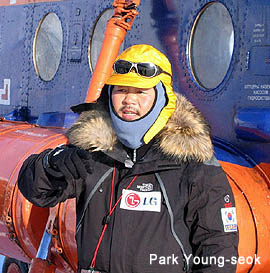
Park Young Seok, the Leader of the Expedition, 44 (a
famous Korean mountaineer and explorer, who climbed 14 highest highest 8000
m peaks of the planet, reached the North and the South Poles). He was accompanied
by the two experienced mountaineers: Oh Hee Jun, 37, (who ascended ten
8000 m peaks ), and Lee Hyeong Mo, 28 (last year he made an ascent to
the summit of the Everest).
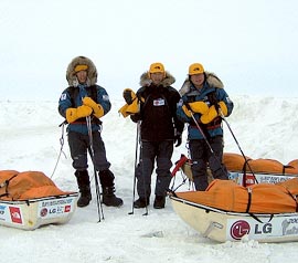
The Expedition started from the Russian coast. On March
5, 2007 at noon the helicopter of the ChukotAvia Company landed the team
on the fast ice near the Dezhnev Cape. The width of the Bering Strait in its
narrowest place is a bit more than 80 km. The explorers did not manage to overcome
this distance during four days.
In winter the space between Chukotka and Alaska is blocked
up with broken ice of various thicknesses. This picture resembles a bog, which
drift yields to strong and changeable wind. Open water spaces can appear quite
suddenly, and they can also quickly freeze under -30 degrees, covering by a
thin film of young ice – too thin to sustain a skier's weight with a backpack,
but firm enough to hinder a sailing in a boat. Only polar bears feel here quite
comfortable and are invariably wandering here in February – March.
The explorers were walking on foot – without skis (they refused
to take them). This was the cause of unplanned swimming of the two team members
in the Chuckchee Sea on the first day of the Expedition, and also hampered the
progress in the future. Nevertheless the start was quite successful. The group
moved directly to the east and passed 12 km from the Dezhnev Cape. The explorers
overcame open water areas by swimming in special dry suits. The weather was
fair, with weak wind. The coordinates of the first night camp: 66°01.100'
N 169°25.090' W.
The first night was disturbed as polar bears were wandering
around a tent and the explorers had to frighten them off by recurring firing
in the air.
In the afternoon every day the team received the weather forecasts
for the coming days, which were prepared in Moscow by K.Golovlev, Director of
the Marine Forecasts Department of the Russian State Hydrometeorological Centre.

The forecast of March 6 indicated strengthening of the south-east
wind, a temperature increase and snowfall. During this night the tent with explorers
was drifted 19 km to the north. Next day the team followed up to the south-east,
but a strong drift carried them to the north. The team estimated that the flow
velocity was 2.5 km/hour. The coordinates in the evening: 66°30.417' N 169°21.457'
W. The explorers were drifted in the Arctic Ocean.
But in the night of March 7 the wind had completely
changed its direction to the opposite. The ice from the north was driven in
the Strait and the team had considerably advanced to the south-east. They
put a tent at the point 66°16.458' N 168°56.470' W in the USA territorial
waters.
 In
the night the north-west wind had increased and a floe with the sleeping team
was drifted 20 km away to the south. On March 8 the team traveled 25
km more, directing to the west extremity of Alaska. No more than 1/3 of the
route was left to the American coast. In the evening the GPS registered the
following coordinates: 65°55.555' N 168°31.162' W.
In
the night the north-west wind had increased and a floe with the sleeping team
was drifted 20 km away to the south. On March 8 the team traveled 25
km more, directing to the west extremity of Alaska. No more than 1/3 of the
route was left to the American coast. In the evening the GPS registered the
following coordinates: 65°55.555' N 168°31.162' W.
This night might have
been a decisive one, determining the Expedition's success. If the travelers
continued their route they could have reached the coast of the American continent
with only 27 km to go. Bit it was impossible to travel in the complete darkness
over rapidly drifting ice.
The wind increased to
the storm strength and the travelers had to support a tent by their own backs.
The morning coordinates: 65°25.176' N 168°25.379' W did not encourage
them. They were blown through a gigantic aerodynamic tube of the Strait exactly
in the middle between Wales (the scheduled finish point) and the Little Diomede
Island. The explorers were drifted to the Pacific Ocean – 50 km of drift during
the night! The further continuation of the expedition was senseless and they
called for a helicopter from Alaska.
For four days the team was drifted in the Strait from the
south to the north and from the north to the south. During this period they
made a 200 km broken line in the basins of the two Oceans.
The organization of this Expedition was based on the experience
of the Expedition, carried out by Dmitry and Matvey Shparo, who were the first
in the world to cross the Bering
Strait in March 1998. The Korean team had sufficient food and petrol
reserves, there were two support groups at Chukotka and Alaska, who had the
Agreement with the local Alaska Helicopter Company to perform rescue and drop
works in case of emergency. The unsuccessful attempt of the Korean team had
once again confirmed that it is dangerous and technically difficult to cross
the Bering Strait in winter. The indirect reason of this failure could have
been absence of skis (Dmitry and Matvey Shparo had successfully crossed the
Bering Strait on skis). Evidently thin ice can withstand with much more probability
a pressure of a traveler on skis, than a traveler on foot.

Based on the Google
Earth map
| |
Lat
|
Lon
|
| 1 |
5 March, 2007 |
morning |
66°01.171' N
|
169°41.247' W
|
| 2 |
|
evening |
66°01.100' N
|
169°25.090' W
|
| 3 |
6 March, 2007 |
morning |
66°11.090' N
|
169°30.450' W
|
| 4 |
|
evening |
66°30.417' N
|
169°21.457' W
|
| 5 |
7 March, 2007 |
morning |
66°28.023' N
|
169°20.020' W
|
| 6 |
|
evening |
66°16.458' N
|
168°56.470' W
|
| 7 |
8 March, 2007 |
morning |
66°05.342' N
|
168°54.551' W
|
| 8 |
|
evening |
65°55.555' N
|
168°31.162' W
|
| 9 |
9 March, 2007 |
morning |
65°25.176' N
|
168°25.379' W
|
| |
Point to evacuations
|
65°18.300' N
|
168°19.260' W
|
See also: www.donga.com